Your Guide to the San Juan Skyway Road Trip
Updated: Nov. 24, 2022
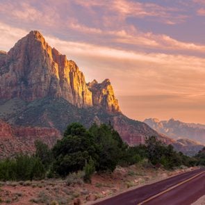
From desert to mountain, you can't beat the San Juan Skyway views.

There’s gold in these hills
The locals call their homeland “Colorful Colorado,” and a drive around the San Juan Skyway loop proves the aptness of the nickname. As you climb from dusty lowlands to snowy peaks, you’ll see nearly every shade possible in nature’s kaleidoscopic palette, from creamy sands and rusty bluffs to multi-hued alpine meadows. Winding through a section of the Rocky Mountains from New Mexico into the southwest corner of Colorado, the San Juan mountains were the site of Colorado’s gold and silver mining boom in the early history of the state.
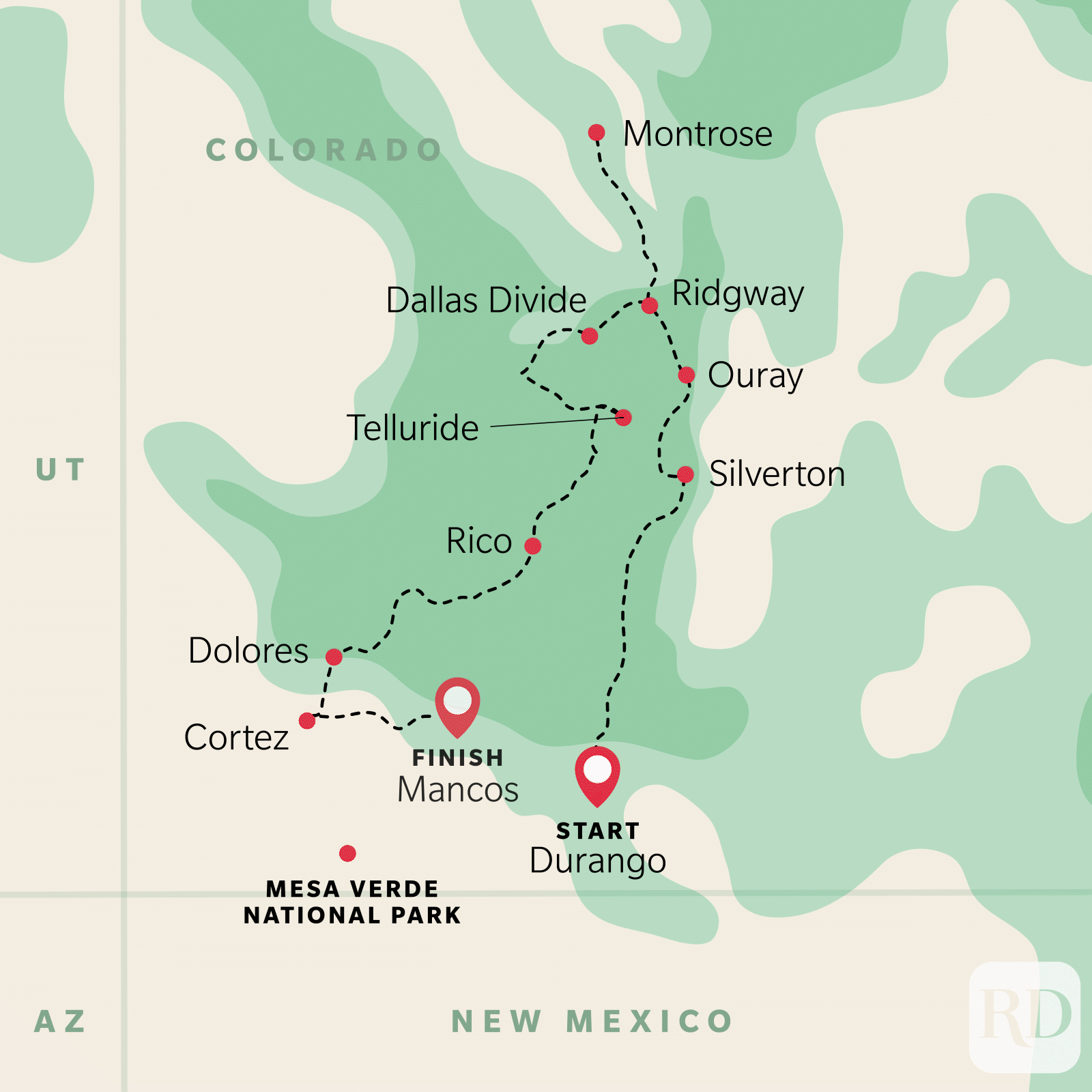
The San Juan Skyway is indisputably one of the best road trips in America. It follows Routes 550, 62, 145, 184, and 160 in a loop traversing through river valleys and alpine peaks. Two million years of periodic glaciation sculpted this awesome landscape, leaving behind precipitous gorges, broad valleys, craggy ridges, and skyscraping peaks. In fact, 14 of Colorado’s famous 58 14ers (peaks above 14,000 feet) are found in the San Juans. Volcanic eruptions played a part as well, spewing lava and ash over the region. Deposits of gold, silver, lead, copper, zinc, and other metals brought wealth to the area, although most of the region’s income now comes from tourist activities and recreation.
See human history dating back over 1000 years
The San Juan Skyway is 233 miles of jaw-dropping overlooks and compelling history. To drive straight through takes around seven hours, but you could easily stretch this into a relaxing two-day jaunt with stops in the many delightful towns and visits to interesting sites along the highway. Two attractions well worth visiting are Chimney Rock Archaeological Area and Canyons of the Ancients National Monument, both near the southern end of the San Juan Skyway, and the Ute Indian Museum, in Montrose, slightly north of Ridgway.
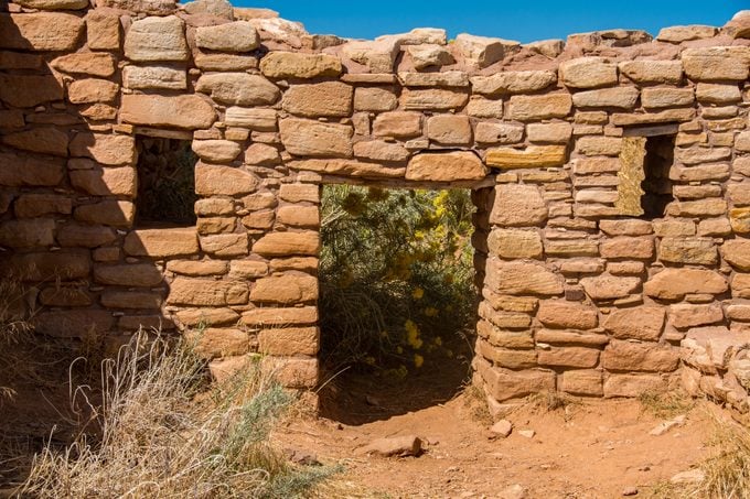
Chimney Rock preserves over 200 ancient homes and buildings of the Ancestral Pueblo peoples of the Chaco Canyon. Many of the buildings have been excavated for viewing, and Chimney Rock itself sits 7,000 feet above sea level (although it’s just a half-mile hike up from the base). At the top, you’ll enjoy breathtaking 360-degree views of New Mexico and Colorado. To the north and west, near the Utah Border lies the Canyons of the Ancients National Monument, and the 1000-year-old Lowry Pueblo Ruins. This is another beautiful and ancient Ancestral Puebloan site. Visitors are able to enter the huge kiva (a circular room used for spiritual purposes and meetings) and be immersed in the history of pre-colonial America.
This beautiful road trip is popular year-round, from winter sports-lovers admiring the snowy peaks as they head to Telluride, to summer vacationers looking for the cool mountain air, but it is an especially beautiful drive in early fall when the aspen leaves turn a bright, rich gold for several weeks and the hills seem to glow, making Colorado one of the best places to see fall foliage. No matter what time of year you take the San Juan Skyway, this route will provide you with beautiful views, amazing food, and fascinating diversions. Here’s what your trip might look like.
Start your trip in Durango
Though Will Rogers once described Durango as “out of the way and glad of it,” by the late 1800s it was a bustling hub. Founded in 1880 by the Denver & Rio Grande Railroad as a hub for the silver and gold mining trade, the trains transported freight and passengers and Durango soon became known for its robust mining industry and natural beauty. Today’s visitors can recall that historic era by strolling through the restored downtown, with its gaslit streetlamps and Victorian shops that sell everything from Mailpouch tobacco to mink earmuffs. Mexican cantinas, Irish pubs, and vintage Old West honky-tonks invoke the days when miners and cattlemen clomped in for a pint of brew. It’s also a great place to pick up anything you forgot to include on your road trip essentials checklist.
Another way to relive the town’s halcyon past is to board the Durango–Silverton Narrow Gauge Railroad, which runs steam trains between May and October, for a daylong round-trip journey through stunning mountain scenery. In one of the great engineering feats of its time, a part of this route was blasted into a sheer rock wall 400 feet above the Animas Canyon. Today, with guests settled into a variety of cars—open gondolas, coaches, or 1882 parlor cars—the train sounds a plaintive whistle as it chugs up the Animas River valley through the San Juan–Rio Grande National Forest, making occasional stops for backpackers. The end of the line is Silverton, a mining town seemingly frozen in time.
Head north through the Animas River Valley
Departing from Durango, the Skyway itself (this section is on Rte. 550) roughly parallels the rail route from Durango to Silverton, meandering along the gorgeous Animas River. Passing by green pastures grazed by cattle and under red-rock cliffs rising abruptly from the valley, the Skyway climbs to the alpine heights of the Durango Mountain Resort, a down-home ski resort whose unpretentious spirit is expressed in the sign declaring “No Movie Stars Here!” The resort used to be called Purgatory, a name which came from the area’s mining heyday, when miners tried to make their way from Durango to Silverton, but stopped at the ski resort when they couldn’t find a way up over the mountains: Hence, they were stuck between two locations—in purgatory. Those miners didn’t have the right vehicle to get over the peaks, but you can avoid purgatory by picking the best car to rent for a road trip.
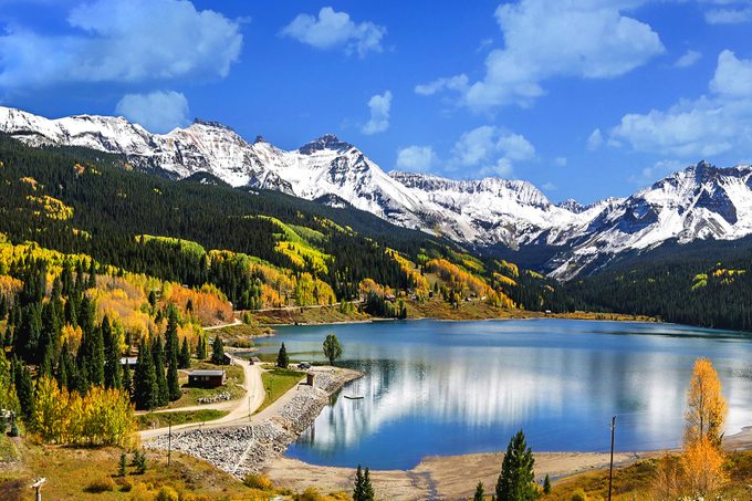
Approaching Silverton, the San Juan Skyway zigzags up to the 10,910-foot Molas Pass, overlooking an array of lofty peaks, ridges staircasing up from the canyon floor, and the turquoise gem known as Molas Lake.
Silverton, rocky mountain high
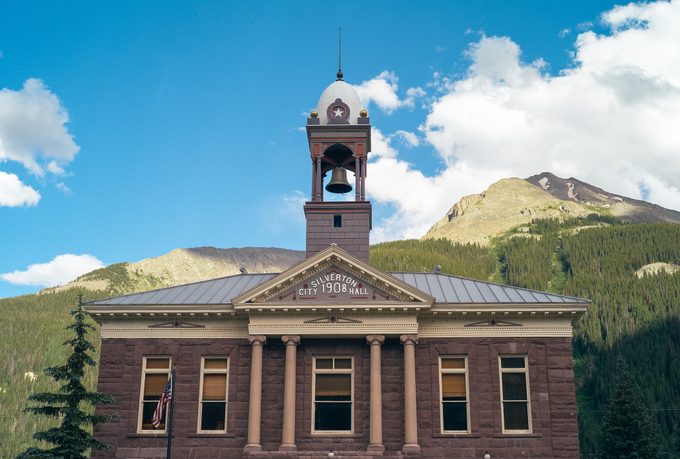
From Molas Pass, the Skyway drops sharply into the town of Silverton, strikingly set between high mountain walls. According to local lore, the town was named by a miner who once exclaimed, “We may not have gold here, but we have silver by the ton.”
The quaint streets of Silverton are lined with historic relics—the gold-domed county courthouse, once-elegant hotels such as the Grand Imperial, and a former red-light district where locals stage mock gunfights on summer evenings. At nearby Hillside Cemetery, perched above town, grave markers tell of young men who lost their lives in mining disasters. As well as history, there are many opportunities for outdoor recreation in the area, such as sledding, skating and skiing in winter, and rafting, camping, and horseback riding in summer, which is also the perfect time to consider a road trip with your dog.
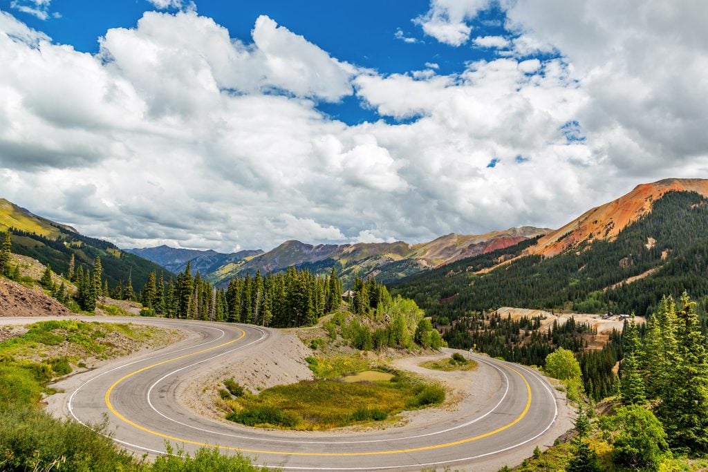
Drive slowly on the Million Dollar Highway
A 25-mile portion of the road between Silverton and Ouray is known as the Million Dollar Highway. Built between 1880 and 1920, the old toll road served as a mail, stage, and freight route. Depending on whom you ask, the highway was named for the amount of gold and silver mined in the area, the value of the low-grade ore tailings used to pave the road, the cost of the construction, or the rewarding views. But despite the splendid scenery, motorists should definitely keep their eyes on the road along this stretch of the San Juan Skyway. It’s narrow (only two lanes wide) and threads around hairpin turns, and even with the height, there are no guard rails. The roads can close unexpectedly, especially in the winter—this is avalanche country! However, as long as you take it slow, the amazing views make the risk worth it. For more information on the Million Dollar Highway road trip see our complete guide.
The mists of Ouray
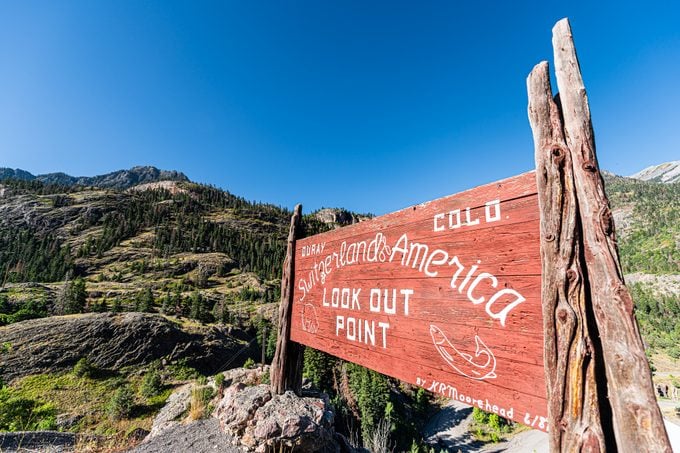
As the highway curlicues down to Ouray, it passes through a tunnel blasted through solid rock, skirts the empty doorways of old mines, and breezes past waterfalls crashing down from invisible heights. Nestled in a narrow, steeply walled valley, Ouray and its environs have been called the “Switzerland of America” (and it’s another great town to pick up anything you missed in your road trip preparation). Its steep streets are lined with Victorian hotels and shops—even a public pool fed by hot springs that send billows of steam into the air, as guests who have come to “take the cure” gaze up at snowcapped peaks. The town is named after a Ute Indian Chief; the Ute people visited the pools often and held ceremonies in the caves.
The popular hike to Box Canyon Falls ends at the stunning waterfall of Clear Creek, thundering 285 feet down a narrow gorge. A steel suspension bridge and well-marked trails offer glorious vistas, especially in autumn when the aspens turn golden.
Outdoor living in Ridgway
From Ouray, the San Juan Skyway leaves the mountains behind and coils into a broad valley where elk and deer graze in verdant meadows. Turning west on Rte. 62, the drive eases into Ridgway, which may look vaguely familiar. This former Wild West town was used to film scenes in a number of Hollywood westerns, including “True Grit” and “How the West Was Won.” If you prefer audiobooks to films, make sure you’ve downloaded these family-friendly audiobooks for your next road trip.
If time permits, follow Rte. 550 north to Montrose and turn east on Rte. 50, to the road that leads to the Black Canyon of the Gunnison National Park (Rte. 347). Here a deep gorge was carved out over 2 million years by the erosive power of the Gunnison River. Its charcoal-gray walls are shrouded in shadow for most of the day, hence the name Black Canyon. One of its prominent features, the 2,200-foot behemoth called the Painted Wall, is the tallest cliff face in Colorado.
High mountain pass: Dallas Divide
From Ridgway, Rte. 62 rolls west past broad ranchlands dotted with cattle, climbs to scrub oaks and aspen, and finally enters the spruce-covered hills of the Dallas Divide. It overlooks the Mt. Sneffels Wilderness Area—an array of jagged, snowcapped peaks whose centerpiece is 14,150-foot Mt. Sneffels (named for a mountain in Jules Verne’s Journey to the Center of the Earth). From the Dallas Divide, the San Juan Skyway descends to cottonwood country and into the tiny town of Placerville, where it turns south on Rte. 145. Make sure you don’t get lost by downloading one of the best road trip apps you can get for free. After several miles, the route veers east to the beautiful resort town of Telluride.
Smugglers blues in Telluride
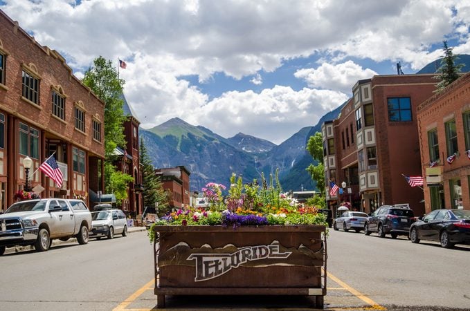
Its fanciful setting and gingerbread architecture give Telluride the kind of ambiance you’d expect from a town that looks like a fairy tale. The quaint streets of this turn-of-the-century town are lined with a mixture of colorful clapboard houses and brick buildings. In spring, melting ice and snow sends waterfalls cascading down the side of the mountains which rise a mile above the valley floor. Some locals claim Telluride is a contraction of “To hell you ride,” a reference to the town’s rowdy past Butch Cassidy robbed his first bank here in 1889). Actually, the town was named after a mineral compound often found with gold and silver that, ironically, is extremely rare in Telluride. The town was the bad boy of the San Juan Skyway for some years, becoming a counterculture haven until it cleaned up its image in the late 1990s.
Because of its remote location, Telluride was once “hell” to get to as well—especially in winter when snowdrifts blocked the winding roads. But thanks in part to a new airport that accommodates small jets, the town has become a popular destination. This may explain why the price of real estate around Telluride has soared higher than the peaks, and why part-time residents include a bevy of high-profile celebrities. The town is shared as well by a new breed of buckaroos: kamikaze skiers and mountain bikers who hurtle themselves down the surrounding slopes. On some days it seems all roads lead to Telluride: the burgeoning ski town is also the Festival Capital of the Rockies, hosting throughout the year a number of world-famous film, arts, music, and even hang-gliding festivals. We recommend stocking up on the best road trip snacks while you’re there. Another must for Telluride visitors with some time on their hands is the relatively easy two-hour round-trip hike to Bridal Veil Falls at the head of the canyon. Accented by rainbows as it plunges off a 425-foot-high cliff, Bridal Veil has the longest freefall of any waterfall in Colorado.
10,000 feet up, the Lizard Head Pass
After retracing the spur from Telluride to continue south on Rte. 145, the San Juan Skyway heads across a high plateau of grasslands and dense aspen groves, with Wilson Peak and Sunshine Mountain towering to the southwest. In spring (mid-June in these parts), lilies and other wildflowers bloom from snowfields amid the tracks of local wildlife.
Farther on, the road passes through the tiny, historic mining town of Ophir, by glistening Trout Lake, and by a campground with the ambitiously Alpine name of Matterhorn. It then climbs to 10,222-foot Lizard Head Pass (named for a reptile-like monolith near the road). Native Americans used the pass for thousands of years, and highway markers note that the Rio Grande Southern Railway passed through here until 1952. If you don’t like heights, road trip games are a great distraction! Several miles ahead, the road twists through a glaciated valley dotted with beaver dams before easing into the pretty town of Rico.
Recreation in Rico
Adopting the Spanish word for “rich,” this once-booming, still-charming silver mining town is lined with stone and brick Victorian structures from the 1880s. This area offers some seriously stunning views along the river. For the next 30 miles or so past Rico, the route follows the Dolores River, which takes a leisurely, meandering course through a valley of aspens and spreading cottonwoods. The river has an abundance of great fishing spots, making it popular with anglers as well as campers, hikers, and other outdoor enthusiasts.
Back down to the desert in Dolores
Heading south and west along the San Juan Skyway, you’ll reach the pleasant town of Dolores perched above McPhee Reservoir, Colorado’s second-largest body of water. Near the San Juan National Forest, Dolores is popular for recreation and the site of ancient ancestral Puebloan settlements. Some of the remains that were excavated here before the gorge was flooded are on display in the Anasazi Heritage Center, located on a bluff overlooking the Montezuma Valley, about four miles south of town on Rte. 145. The center also features a 25-room ruin and a full-scale replica of a pit house dwelling.
Descending past ranches and farms, the drive reaches the small town of Cortez, popular with tourists visiting the ancient historical and archaeological sites in the area. Also nearby are scenic desert-scapes, backed by the La Plata Mountains and unique Mesa Verde National Park. On a mission to fill up your National Parks passport? These are the best National Park road trips to take all year long.
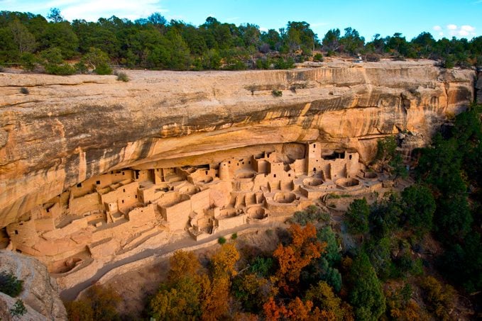
Mesa Verde National Park
More than 700 years have passed since the Ancient Pueblo peoples occupied cliff dwellings along Mesa Verde’s precipitous walls, but many of the buildings are perfectly preserved, such as the huge Cliff Palace, which once housed over 200 people. Visitors can roam through apartment-like cliff dwellings built in the 12th century, carefully oriented south-southwest to maximize the low winter sun and protect from the summer heat. At the Chapin Mesa Museum, lifelike dioramas and various exhibits on basket weaving, pottery, masonry, and other skills trace the evolution of Ancient Puebloan culture from its beginnings, in settlements along the Colorado River. Around 35,000 descendants of these ancient peoples, who identify as Pueblo, are estimated to live nearby in New Mexico and Arizona. As well as amazing archaeological sites, beautiful mesas dot the landscape, a paradise for hikers and campers.
Mancos, the Gateway to Mesa Verde
From Mesa Verde National Park, the drive continues east on Rte. 160 to a lush valley occupied by the historic ranching town of Mancos, which exudes Old West ambiance. Nearby Mancos Lake State Park has a lovely campground in the midst of a ponderosa pine forest, and the lake itself is a paradise for boaters and anglers.
Heading east again, the road passes through ranchland and aromatic sagebrush flats to Cherry Creek, the locale where novelist Louis L’Amour penned the westerns that immortalized southwestern Colorado, such as the “Hopalong Cassidy” series. The wide-open spaces continue all the way to Durango, the drive’s point of origin. Thrilled by the captivating views along the San Juan Skyway, many a motorist has simply turned around and driven the entire route back in the opposite direction. Next, make sure you’re prepared for every eventuality with our ultimate guide to planning your road trip.